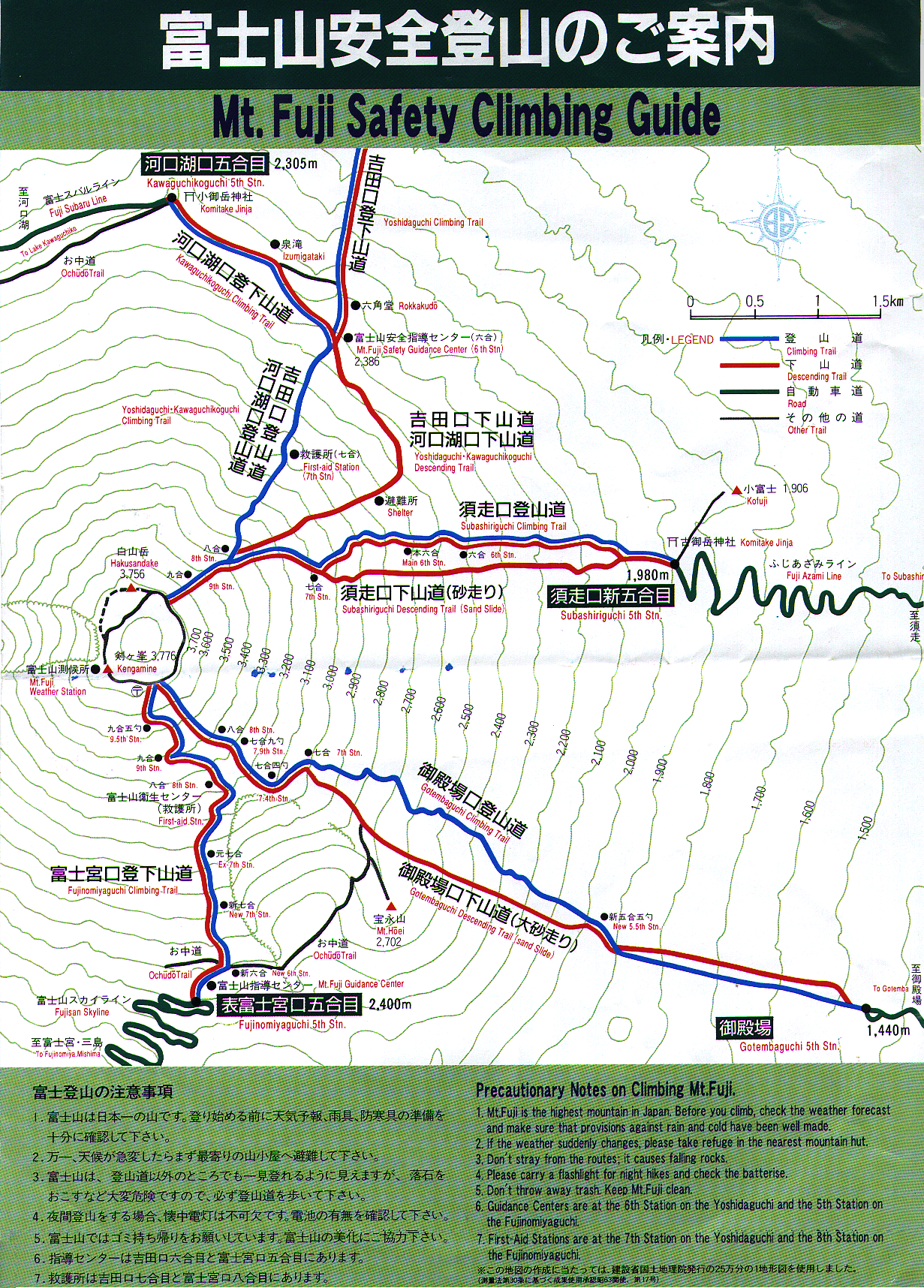
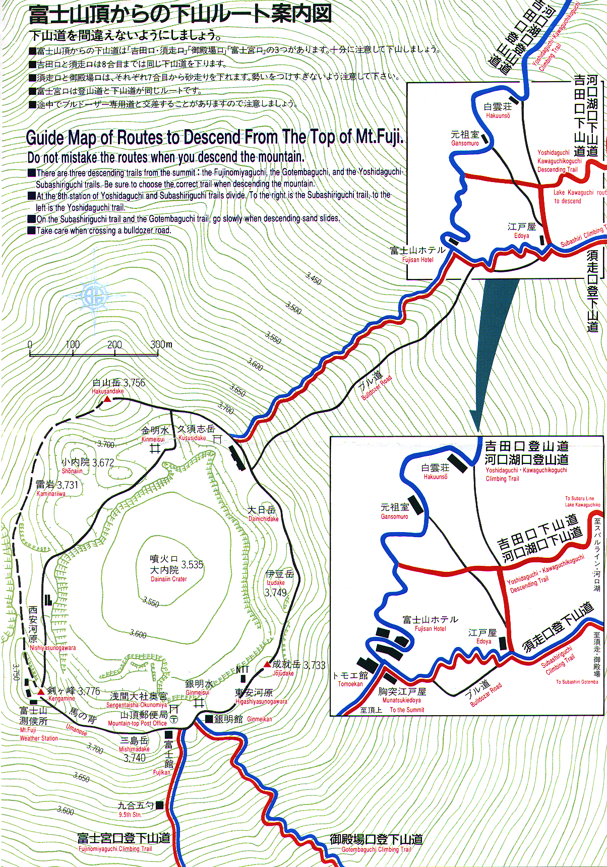
Fuji Trails link
-
Fuji Summit link
I chose to start climbing at Kawaguchiko-fifth-station. (the mountain elevation is
divided into 10 "stations" with Station 10 being the top.) Most of the trails
start at the 5th station level, so I wasn't cheating or anything...
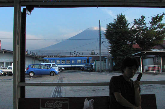
It took 3 different train lines and one bus ride to get there, with 5
different transfers along the way. Here is a photo I took while waiting for
that 5th transfer to the bus that goes to Kawaguchiko 5th Station. The train I
arrived on is in the middle background. There is moist air blowing in, as seen
by the cloud-crown on Fujisan.
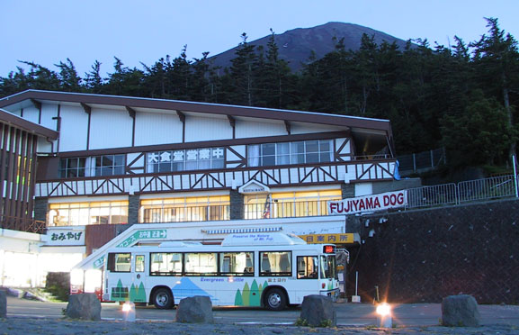
This is the end of the $10 bus ride (and that's the bus I rode in on...) There
are actually several buildings there (all with the Swiss Chalet look,) and
I have the pictures to prove it. But if you've seen one faux-Swiss Chalet
building, you've seen 'em all.
There was a group of hippy-looking young adults (bandannas, tie-dye ponchos,
homemade jewelry -- think 'dead-heads',) getting ready to climb. Members of
this group were carrying traditional Japanese musical instruments, and at
times along lower part of the trail I'd hear those instruments being played. I
stopped hearing them being played at about the 7th Station level, although I
kept passing/being passed by that group until we reached the summit.
It was about 8:15 pm. I decided to start the climb.
I didn't want to have to hurry to reach the summit in time for the sunrise.
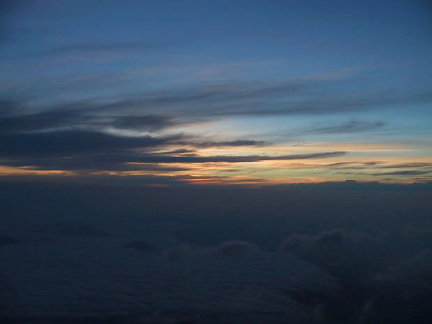
It was a nice night out. There was no moon, but the sky was clear.
I decided to not use my flashlight and just use night vision. I rounded a
corner of the trail and saw this scene above me...

The topmost group of lights are actually on the top of Fujisan. The photo was an
8-second exposure.
On this page (sorry, dead link) is the
listing of ALL the huts on EVERY climbing route on Fujisan.
Count the number of huts within the 8th Station level... (there were about 7
huts within the '8th station' band).
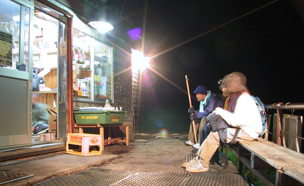
This is hut #5 on the Kawaguchiko list on the above website
This is what most of the huts looked like -- the trail (or 'track' as it's
referred to,) would cross in front of the hut, giving the salesmen in the hut maximum
exposure to the passing hikers. Believe me, inside every hut I passed were a
bunch of hikers (between 50 and 300 in each hut,) who had hiked up that far earlier in the day and
had paid approximately $40 each for the privilege of sleeping on a small futon
until 1 or 2 am, when they would arise to eat breakfast and continue the climb to the
summit. The idea was to reach the summit in
time to watch the sun rise from there.
Some of the huts were close to each other, some were farther apart. I think
this next picture was taken at the lowest "Fujisan Hotel", as there is quite a
gap between it and the next lower group of huts.
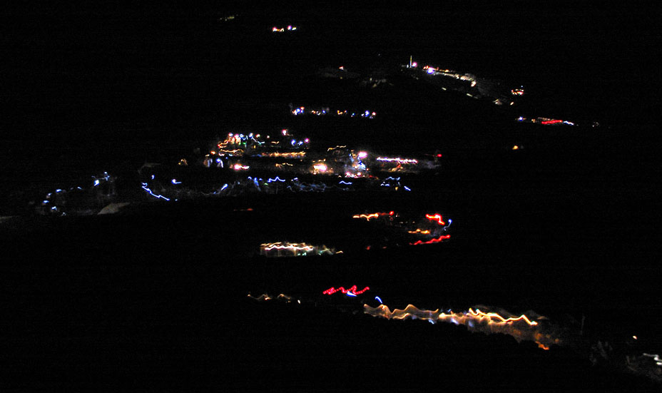
What you're looking at is the line of hikers who, at 2:15 am, are making their
way up the trail. (8-second exposure, and the camera's pointed downward at at
least a 45-degree angle.) After 2 am the trail got really crowded, what
with all the climbers who had spent the night in one of the 14 huts getting up
and trying to complete their climb before sunrise.
The various tour leaders had 'sticks' with flashing red LED's in them. You can see one
of those sticks in the middle of the picture - look for the deep-red lines.
Every member in another tour group had the same identical brand of 'white' LED
headlamp. Look for the long line of bluish streaks (the 'white' LED's show up
as blue in this photograph.) By this point in the hike, my night vision was
wrecked by the lighting at the huts and by the other climbers' lights, but it
didn't matter because I could see perfectly well from everyone else's sources
of illumination. I had to say 'sources of illumination', because I saw about
every type of headlight, flashlight, and portable lamp on that hike -- one guy
was even using a kerosene safety lantern! Really!
I'm glad they had this sign in the toilet, as I would hate to have been thrown into
the blackhole (seeing as how my last name is SAVAGE... ;-)
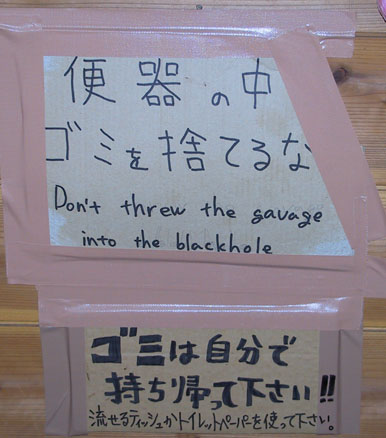
The other sign basically says if you brought it with you, take it back down
with you (meaning your garbage.)
By the time I reached the summit (at about 4:20 am,) the lack of sleep and deprivation of some oxygen
made me feel like I was lugging a ton of bricks around. All the good spots
along the huts were already taken by previous arrivees, so I made my way along
the rim of the summit to a place where I could hole up out of the freezing
wind and - just - sit - for - a - little - bit (*whew*)...
Here are two pictures I snapped while waiting and trying to
stay awake.
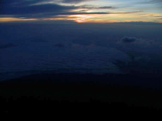
DAMN AUTOFOCUS!!! Here's the sunrise -- blurry as hell (@%*@&$$!)
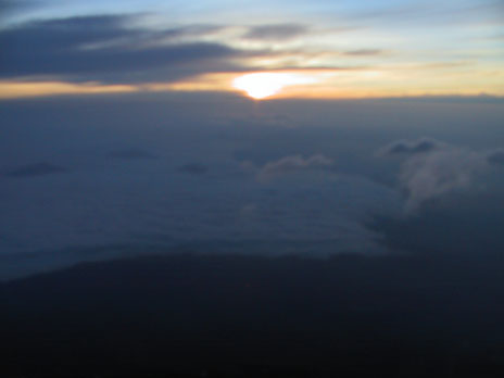
At the moment of sunrise, spontaneous shouts of "BANZAI!" arose from the
hundreds of climbers. I switched my camera to MOVIE mode and captured
some of the revelry, then
bought a $7.25 bowl of
Top Ramen for 'breakfast' and went to the descending route I'd chosen.
Sunrise movie - 340KB - Some of these people had (like me) climbed overnight to be here at sunrise. What a crazy bunch!
Along the way to my chosen descent track, I snapped this shot of the crater.
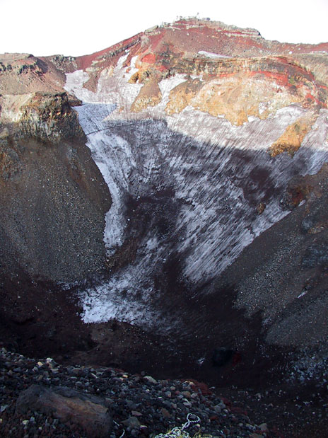
Somebody told me there's a Bhuddist or Shinto temple in the bottom of the
crater. No. There
are several several shrines along the rim, though. The buildings on the peak
in the above picture are
a weather observation station and an NHK broadcast facility. No, I didn't go
there.
The route back down was longer than the route up, with fewer hikers either
coming or going, and WAY fewer huts along the way.
Most of the hikers I saw coming up I saw while I was still near the summit. Farther down, I was
by myself most of
the time. I chose this route to make a loop (I hate out-and-back-the-same-way
hikes because it
always seems longer going back,) and to check out the 'Sand-Run' (Sunabashiri).
BIG MISTAKE!
With my pack, my collection of pre-blisters (thank you, thank you, Dr.
Scholl's MoleFoam, for
keeping them from becoming post-blisters!), and a knee that was telling me
"You'll be
SOR-R-EEE!!", there was no way I could run down that part of the trail. Also
there was mist
blowing in. At times it was bad enough that the brim of my hat was raining.
What made it worse was that, without a good horizon reference, the trail
didn't look as steep as
it was. I was walking down a long, long alluvial plane that stayed pretty much
at the same
angle. The route was marked with poles planted vertically in the loose gravel.
I decided that
humans the world over have a need to make sure that a pole is plumb, and that
I should use the
pole to determine my angle of descent...
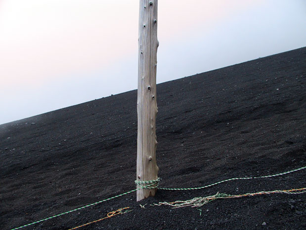
WOW! A lot steeper than it appeared as I was looking down that long trail.
Finally I passed the new 5th station (the owner was desperate to get me to buy
something/anything, and I was desperate to make the one bus of the day from
the bus stop a
quarter mile farther down to the train station in Gotemba (or 'Gotenba',
depending...) and made
it to that bus stop in time for the bus.
The rest of the trip was by train. I skillfully slept on the train, waking up
just in time to
make the transfer from the express train to the local I needed to get to
Sobudai-Mae station.
That night I slept 10 hours.
My calves, knees and feet were sore for four days. The danged mountain kicked my butt
going up, kicked
it again while I was at the top, and kicked it still again all the way back
down.
Glad I did it...